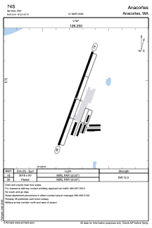
ADC chart of 74S
 Satellite view of 74S

Satellite view of 74S
Sorry, we have no imagery here.
Sorry, we have no imagery here.
Sorry, we have no imagery here.
Sorry, we have no imagery here.
Sorry, we have no imagery here.
Sorry, we have no imagery here.


74S - Anacortes
Located in Anacortes, United States
ICAO - 74S, IATA -
Data provided by AirmateGeneral information
Coordinates: N48°29'55" W122°39'45"
Elevation is 246 feet MSL.
Magnetic variation is 21° East View others Airports in Washington
Operational data
Special qualification required
Current time UTC: 14:51:46
Current local time:
Weather at : KNUW - Whidbey Island Nas (Ault Fld) ( 16 km )
METAR: KNUW 301353Z 00000KT 10SM SCT150 10/08 A3026 RMK AO2 SLP251 T01000083 $
TAF: TAF KNUW 3007/3107 VRB06KT 9999 FEW100 SCT230 QNH3019INS BECMG 3019/3021 27009KT 9999 FEW035 BKN230 QNH3006INS TX18/3023Z TN08/3013Z FS30236
Communications frequencies: [VIEW]
Runways:
| RWY identifier | QFU | Length (ft) | Width (ft) | Surface | LDA (ft) |
| 18 | 200° | 3018 | 60 | ASPH | |
| 36 | 20° | 3018 | 60 | ASPH |
Airport contact information
Address: Anacortes United States
Satellite view of 74S
Sorry, we have no imagery here.
Sorry, we have no imagery here.
Sorry, we have no imagery here.
Sorry, we have no imagery here.
Sorry, we have no imagery here.
Sorry, we have no imagery here.