ADC chart of 73S
 Satellite view of 73S
Satellite view of 73S
Sorry, we have no imagery here.
Sorry, we have no imagery here.
Sorry, we have no imagery here.
Sorry, we have no imagery here.
Sorry, we have no imagery here.
Sorry, we have no imagery here.


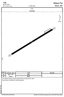
73S - Willard Fld
Located in Tekoa, United States
ICAO - 73S, IATA -
Data provided by AirmateGeneral information
Coordinates: N47°14'8" W117°2'38"
Elevation is 2520 feet MSL.
Magnetic variation is 19° East View others Airports in Washington
Operational data
Special qualification required
Current time UTC: 00:19:44
Current local time:
Weather at : KSFF - Felts Fld ( 54 km )
METAR: KSFF 242353Z VRB03KT 10SM CLR 26/00 A3000 RMK AO2 SLP151 T02610000 10261 20217 56015 $
TAF: KSFF 242320Z 2500/2524 06006KT P6SM SKC
Communications frequencies: [VIEW]
Runways:
| RWY identifier | QFU | Length (ft) | Width (ft) | Surface | LDA (ft) |
| 04 | 59° | 2261 | 40 | ASPH | |
| 22 | 239° | 2261 | 40 | ASPH |
Airport contact information
Address: Tekoa United States
Satellite view of 73S
Sorry, we have no imagery here.
Sorry, we have no imagery here.
Sorry, we have no imagery here.
Sorry, we have no imagery here.
Sorry, we have no imagery here.
Sorry, we have no imagery here.