ADC chart of 70S
 Satellite view of 70S

Satellite view of 70S
Sorry, we have no imagery here.
Sorry, we have no imagery here.
Sorry, we have no imagery here.
Sorry, we have no imagery here.
Sorry, we have no imagery here.
Sorry, we have no imagery here.


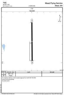
70S - Mead Flying Service
Located in Mead, United States
ICAO - 70S, IATA -
Data provided by AirmateGeneral information
Coordinates: N47°47'14" W117°21'29"
Elevation is 1905 feet MSL.
Magnetic variation is 19° East View others Airports in Washington
Operational data
Special qualification required
Current time UTC: 08:21:45
Current local time:
Weather at : KSFF - Felts Fld ( 12 km )
METAR: KSFF 300753Z AUTO 00000KT 10SM CLR 12/05 A3015 RMK AO2 SLP198 T01220050 402670122
TAF: KSFF 300525Z 3006/3106 24004KT P6SM FEW250 FM301200 VRB02KT P6SM FEW250 FM302000 20004KT P6SM FEW250
Communications frequencies: [VIEW]
Runways:
| RWY identifier | QFU | Length (ft) | Width (ft) | Surface | LDA (ft) |
| 16 | 180° | 2481 | 30 | ASPH | |
| 34 | 360° | 2481 | 30 | ASPH |
Airport contact information
Address: Mead United States
Satellite view of 70S
Sorry, we have no imagery here.
Sorry, we have no imagery here.
Sorry, we have no imagery here.
Sorry, we have no imagery here.
Sorry, we have no imagery here.
Sorry, we have no imagery here.