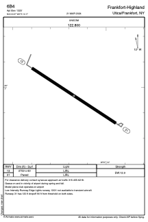
ADC chart of 6B4
 Satellite view of 6B4

Satellite view of 6B4
Sorry, we have no imagery here.
Sorry, we have no imagery here.
Sorry, we have no imagery here.
Sorry, we have no imagery here.
Sorry, we have no imagery here.


6B4 - Frankfort-Highland
Located in Utica/Frankfort, United States
ICAO - 6B4, IATA -
Data provided by AirmateGeneral information
Coordinates: N43°0'58" W75°10'10"
Elevation is 1325 feet MSL.
Magnetic variation is -13° East View others Airports in New York
Operational data
Special qualification required
Current time UTC: 19:40:56
Current local time:
Weather at : KRME - Griffiss Intl ( 31 km )
METAR: KRME 211853Z 11014G21KT 10SM OVC032 12/07 A2994 RMK AO2 SLP139 T01220072
TAF: KRME 211747Z 2118/2218 11008KT P6SM SCT015 OVC040 TEMPO 2118/2120 5SM -RA BR OVC025 FM212000 11010G17KT 5SM -RA BR OVC025 TEMPO 2120/2122 OVC035 FM220400 11010G20KT 5SM -RA BR FEW009 BKN015 FM220700 11010G20KT 5SM -RA BR OVC009
Communications frequencies: [VIEW]
Runways:
| RWY identifier | QFU | Length (ft) | Width (ft) | Surface | LDA (ft) |
| 13 | 123° | 2750 | 60 | ASPH | |
| 31 | 303° | 2750 | 60 | ASPH |
Airport contact information
Address: Utica/Frankfort United States
Satellite view of 6B4
Sorry, we have no imagery here.
Sorry, we have no imagery here.
Sorry, we have no imagery here.
Sorry, we have no imagery here.
Sorry, we have no imagery here.