ADC chart of 69S
 Satellite view of 69S

Satellite view of 69S
Sorry, we have no imagery here.
Sorry, we have no imagery here.
Sorry, we have no imagery here.
Sorry, we have no imagery here.
Sorry, we have no imagery here.
Sorry, we have no imagery here.


69S - Avey Fld
Located in Laurier, United States
ICAO - 69S, IATA -
Data provided by AirmateGeneral information
Coordinates: N48°59'54" W118°13'21"
Elevation is 1655 feet MSL.
Magnetic variation is 20° East View others Airports in Washington
Operational data
Special qualification required
Current time UTC: 02:46:30
Current local time:
Weather at : CYCG - West Kootenay Regional ( 54 km )
METAR: CYCG 290200Z 34005KT 15SM FEW050 FEW240 30/12 A2980 RMK CF1CI1 CF TR CI TR SLP087 DENSITY ALT 3900FT
TAF: TAF CYCG 290040Z 2901/2904 36006KT P6SM FEW050 RMK NXT FCST BY 291500Z
Communications frequencies: [VIEW]
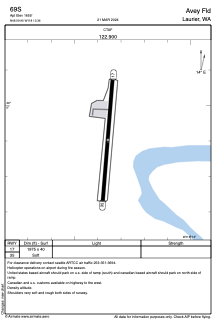
Runways:
| RWY identifier | QFU | Length (ft) | Width (ft) | Surface | LDA (ft) |
| 17 | 185° | 1975 | 40 | GRAVEL | |
| 35 | 5° | 1975 | 40 | GRAVEL |
Airport contact information
Address: Laurier United States
Satellite view of 69S
Sorry, we have no imagery here.
Sorry, we have no imagery here.
Sorry, we have no imagery here.
Sorry, we have no imagery here.
Sorry, we have no imagery here.
Sorry, we have no imagery here.