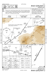
IAC chart of 67L
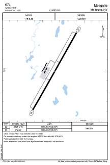
 ADC chart of 67L
 Satellite view of 67L

ADC chart of 67L
Satellite view of 67L
Sorry, we have no imagery here.
Sorry, we have no imagery here.
Sorry, we have no imagery here.
Sorry, we have no imagery here.
Sorry, we have no imagery here.
Sorry, we have no imagery here.


67L - Mesquite
Located in Mesquite, United States
ICAO - 67L, IATA -
Data provided by AirmateGeneral information
Coordinates: N36°49'59" W114°3'21"
Elevation is 1978 feet MSL.
Magnetic variation is 11° East View others Airports in Nevada
Operational data
Special qualification required
Current time UTC: 11:53:57
Current local time:
Weather at : KSGU - St George Rgnl ( 53 km )
METAR: KSGU 241056Z AUTO 11005KT 10SM CLR 22/M10 A2982 RMK AO2 SLP059 T02221100
TAF: KSGU 241125Z 2412/2512 VRB05KT P6SM BKN200 FM242000 24010G18KT P6SM SCT200 FM250200 25007KT P6SM SCT200 FM250500 14005KT P6SM SCT200
Communications frequencies: [VIEW]
Runways:
| RWY identifier | QFU | Length (ft) | Width (ft) | Surface | LDA (ft) |
| 02 | 29° | 5121 | 75 | ASPH | |
| 20 | 209° | 5121 | 75 | ASPH | |
| H1 | 0° | 0 | 0 | UNK |
Airport contact information
Address: Mesquite United States
Satellite view of 67L
Sorry, we have no imagery here.
Sorry, we have no imagery here.
Sorry, we have no imagery here.
Sorry, we have no imagery here.
Sorry, we have no imagery here.
Sorry, we have no imagery here.