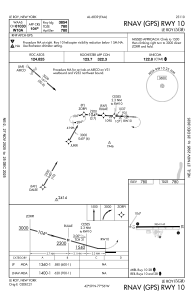
IAC chart of 5G0
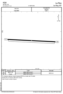
 ADC chart of 5G0
 Satellite view of 5G0

ADC chart of 5G0
Satellite view of 5G0
Sorry, we have no imagery here.
Sorry, we have no imagery here.
Sorry, we have no imagery here.
Sorry, we have no imagery here.
Sorry, we have no imagery here.
Sorry, we have no imagery here.


5G0 - Le Roy
Located in Le Roy, United States
ICAO - 5G0, IATA -
Data provided by AirmateGeneral information
Coordinates: N42°58'53" W77°56'7"
Elevation is 780 feet MSL.
Magnetic variation is -11° East View others Airports in New York
Operational data
Special qualification required
Current time UTC: 09:55:12
Current local time:
Weather at : KGVQ - Genesee County ( 20 km )
METAR: KGVQ 240918Z AUTO 27014G20KT 10SM BKN010 OVC023 08/07 A2992 RMK AO2 CIG 006V012 PNO $
Communications frequencies: [VIEW]
Runways:
| RWY identifier | QFU | Length (ft) | Width (ft) | Surface | LDA (ft) |
| 10 | 93° | 3854 | 60 | ASPH | |
| 28 | 273° | 3854 | 60 | ASPH |
Airport contact information
Address: Le Roy United States
Satellite view of 5G0
Sorry, we have no imagery here.
Sorry, we have no imagery here.
Sorry, we have no imagery here.
Sorry, we have no imagery here.
Sorry, we have no imagery here.
Sorry, we have no imagery here.