ADC chart of 5B1
 Satellite view of 5B1

Satellite view of 5B1
Sorry, we have no imagery here.
Sorry, we have no imagery here.
Sorry, we have no imagery here.
Sorry, we have no imagery here.
Sorry, we have no imagery here.
Sorry, we have no imagery here.


5B1 - John H Boylan State (Island Pond)
Located in Island Pond, United States
ICAO - 5B1, IATA -
Data provided by AirmateGeneral information
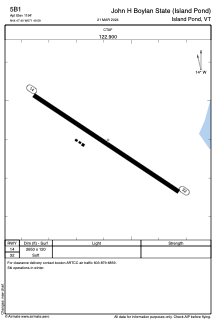
Coordinates: N44°47'24" W71°49'35"
Elevation is 1194 feet MSL.
Magnetic variation is -17° East View others Airports in Vermont
Operational data
Special qualification required
Current time UTC: 04:41:11
Current local time:
Weather at : KCDA - Caledonia County ( 29 km )
METAR: KCDA 300435Z AUTO 00000KT 10SM SCT026 SCT031 OVC070 13/12 A2981 RMK AO2 T01250117
Communications frequencies: [VIEW]
Runways:
| RWY identifier | QFU | Length (ft) | Width (ft) | Surface | LDA (ft) |
| 14 | 124° | 2650 | 120 | GRASS | |
| 32 | 304° | 2650 | 120 | GRASS |
Airport contact information
Address: Island Pond United States
Satellite view of 5B1
Sorry, we have no imagery here.
Sorry, we have no imagery here.
Sorry, we have no imagery here.
Sorry, we have no imagery here.
Sorry, we have no imagery here.
Sorry, we have no imagery here.