ADC chart of 4W0
 Satellite view of 4W0
Satellite view of 4W0
Sorry, we have no imagery here.
Sorry, we have no imagery here.
Sorry, we have no imagery here.
Sorry, we have no imagery here.
Sorry, we have no imagery here.
Sorry, we have no imagery here.


4W0 - Bandera State
Located in Bandera, United States
ICAO - 4W0, IATA -
Data provided by AirmateGeneral information
Coordinates: N47°23'43" W121°32'11"
Elevation is 1636 feet MSL.
Magnetic variation is 20° East View others Airports in Washington
Operational data
Special qualification required
Current time UTC: 23:56:04
Current local time:
Weather at : KRNT - Renton Muni ( 52 km )
METAR: KRNT 252253Z COR 18009KT 10SM CLR 21/08 A2995 RMK AO2 SLP148 T02060083
Communications frequencies: [VIEW]
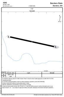
Runways:
| RWY identifier | QFU | Length (ft) | Width (ft) | Surface | LDA (ft) |
| 08 | 0° | 2344 | 100 | GRASS | |
| 26 | 0° | 2344 | 100 | GRASS |
Airport contact information
Address: Bandera United States
Satellite view of 4W0
Sorry, we have no imagery here.
Sorry, we have no imagery here.
Sorry, we have no imagery here.
Sorry, we have no imagery here.
Sorry, we have no imagery here.
Sorry, we have no imagery here.