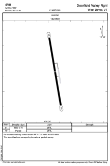
ADC chart of 4V8
 Satellite view of 4V8

Satellite view of 4V8
Sorry, we have no imagery here.
Sorry, we have no imagery here.
Sorry, we have no imagery here.
Sorry, we have no imagery here.
Sorry, we have no imagery here.
Sorry, we have no imagery here.


4V8 - Deerfield Valley Rgnl
Located in West Dover, United States
ICAO - 4V8, IATA -
Data provided by AirmateGeneral information
Coordinates: N42°55'38" W72°51'56"
Elevation is 1953 feet MSL.
Magnetic variation is -15° East View others Airports in Vermont
Operational data
Special qualification required
Current time UTC: 03:55:00
Current local time:
Weather at : KDDH - William H Morse State ( 31 km )
METAR: KDDH 280254Z AUTO 00000KT 10SM CLR 13/09 A3028 RMK AO2 SLP252 T01280089 53005
Communications frequencies: [VIEW]
Runways:
| RWY identifier | QFU | Length (ft) | Width (ft) | Surface | LDA (ft) |
| 01 | 350° | 2650 | 75 | ASPH | |
| 19 | 170° | 2650 | 75 | ASPH |
Airport contact information
Address: West Dover United States
Satellite view of 4V8
Sorry, we have no imagery here.
Sorry, we have no imagery here.
Sorry, we have no imagery here.
Sorry, we have no imagery here.
Sorry, we have no imagery here.
Sorry, we have no imagery here.