ADC chart of 44T
 Satellite view of 44T

Satellite view of 44T
Sorry, we have no imagery here.
Sorry, we have no imagery here.
Sorry, we have no imagery here.
Sorry, we have no imagery here.
Sorry, we have no imagery here.
Sorry, we have no imagery here.


44T - Hoskins Fld
Located in Olympia, United States
ICAO - 44T, IATA -
Data provided by AirmateGeneral information
Coordinates: N46°59'33" W122°49'40"
Elevation is 213 feet MSL.
Magnetic variation is 20° East View others Airports in Washington
Operational data
Special qualification required
Current time UTC: 16:34:59
Current local time:
Weather at : KOLM - Olympia Rgnl ( 6 km )
METAR: KOLM 251554Z 20007KT 10SM OVC040 13/08 A3003 RMK AO2 SLP170 T01330078
TAF: KOLM 251132Z 2512/2612 VRB03KT P6SM BKN200 FM251900 22008KT P6SM BKN120 FM260300 22008KT P6SM BKN050 OVC080 FM261100 22008KT P6SM -SHRA BKN015 OVC030
Communications frequencies: [VIEW]
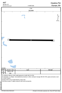
Runways:
| RWY identifier | QFU | Length (ft) | Width (ft) | Surface | LDA (ft) |
| 07 | 91° | 2015 | 116 | GRASS | |
| 25 | 271° | 2015 | 116 | GRASS |
Airport contact information
Address: Olympia United States
Satellite view of 44T
Sorry, we have no imagery here.
Sorry, we have no imagery here.
Sorry, we have no imagery here.
Sorry, we have no imagery here.
Sorry, we have no imagery here.
Sorry, we have no imagery here.