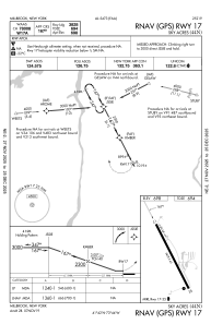
IAC chart of 44N
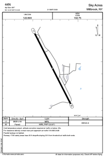
 ADC chart of 44N
 Satellite view of 44N

ADC chart of 44N
Satellite view of 44N
Sorry, we have no imagery here.
Sorry, we have no imagery here.
Sorry, we have no imagery here.
Sorry, we have no imagery here.
Sorry, we have no imagery here.
Sorry, we have no imagery here.


44N - Sky Acres
Located in Millbrook, United States
ICAO - 44N, IATA -
Data provided by AirmateGeneral information
Coordinates: N41°42'27" W73°44'17"
Elevation is 697 feet MSL.
Magnetic variation is -14° East View others Airports in New York
Operational data
Special qualification required
Current time UTC: 09:11:43
Current local time:
Weather at : KPOU - Hudson Valley Rgnl ( 15 km )
METAR: KPOU 290853Z 36003KT 10SM OVC007 13/12 A3009 RMK AO2 SLP187 T01280117 58013
TAF: KPOU 290720Z 2907/3006 01003KT 2SM -RA BR OVC010 TEMPO 2910/2914 OVC025 FM291400 02003KT P6SM -SHRA OVC015 FM291900 23005KT P6SM BKN025
Communications frequencies: [VIEW]
Runways:
| RWY identifier | QFU | Length (ft) | Width (ft) | Surface | LDA (ft) |
| 17 | 153° | 3828 | 60 | ASPH | |
| 35 | 333° | 3828 | 60 | ASPH |
Airport contact information
Address: Millbrook United States
Satellite view of 44N
Sorry, we have no imagery here.
Sorry, we have no imagery here.
Sorry, we have no imagery here.
Sorry, we have no imagery here.
Sorry, we have no imagery here.
Sorry, we have no imagery here.