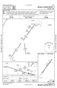
IAC chart of 2S8
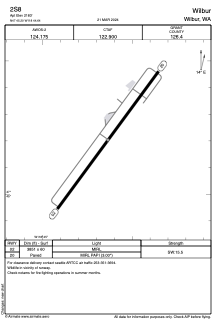
 ADC chart of 2S8
 Satellite view of 2S8
ADC chart of 2S8
Satellite view of 2S8
Sorry, we have no imagery here.
Sorry, we have no imagery here.
Sorry, we have no imagery here.
Sorry, we have no imagery here.
Sorry, we have no imagery here.
Sorry, we have no imagery here.


2S8 - Wilbur
Located in Wilbur, United States
ICAO - 2S8, IATA -
Data provided by AirmateGeneral information
Coordinates: N47°45'12" W118°44'38"
Elevation is 2183 feet MSL.
Magnetic variation is 15° East View others Airports in Washington
Operational data
Special qualification required
Current time UTC: 01:03:55
Current local time:
Weather at : KMWH - Grant County Intl ( 74 km )
METAR: KMWH 230052Z 23007KT 10SM CLR 20/03 A2999 RMK AO2 SLP154 T02000033
TAF: KMWH 222320Z 2300/2324 19007KT P6SM SCT090 FM230200 16006KT P6SM FEW070 FM230500 VRB04KT P6SM FEW070 SCT250 FM232000 19007KT P6SM FEW070
Communications frequencies: [VIEW]
Runways:
| RWY identifier | QFU | Length (ft) | Width (ft) | Surface | LDA (ft) |
| 02 | 36° | 3851 | 60 | ASPH | |
| 20 | 216° | 3851 | 60 | ASPH |
Airport contact information
Address: Wilbur United States
Satellite view of 2S8
Sorry, we have no imagery here.
Sorry, we have no imagery here.
Sorry, we have no imagery here.
Sorry, we have no imagery here.
Sorry, we have no imagery here.
Sorry, we have no imagery here.