ADC chart of 21W
 Satellite view of 21W
Satellite view of 21W
Sorry, we have no imagery here.
Sorry, we have no imagery here.
Sorry, we have no imagery here.
Sorry, we have no imagery here.
Sorry, we have no imagery here.
Sorry, we have no imagery here.


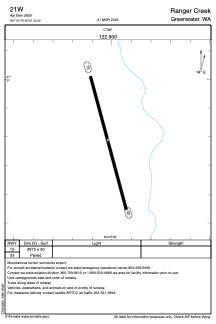
21W - Ranger Creek
Located in Greenwater, United States
ICAO - 21W, IATA -
Data provided by AirmateGeneral information
Coordinates: N47°0'47" W121°32'1"
Elevation is 2650 feet MSL.
Magnetic variation is 19° East View others Airports in Washington
Operational data
Special qualification required
Current time UTC: 20:51:21
Current local time:
Weather at : KPLU - Pierce County/Thun Fld ( 58 km )
METAR: KPLU 252035Z AUTO VRB04KT 10SM BKN045 19/09 A3000 RMK AO2
Communications frequencies: [VIEW]
Runways:
| RWY identifier | QFU | Length (ft) | Width (ft) | Surface | LDA (ft) |
| 15 | 164° | 2875 | 30 | ASPH | |
| 33 | 344° | 2875 | 30 | ASPH |
Airport contact information
Address: Greenwater United States
Satellite view of 21W
Sorry, we have no imagery here.
Sorry, we have no imagery here.
Sorry, we have no imagery here.
Sorry, we have no imagery here.
Sorry, we have no imagery here.
Sorry, we have no imagery here.