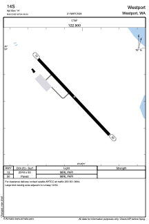
ADC chart of 14S
 Satellite view of 14S

Satellite view of 14S
Sorry, we have no imagery here.
Sorry, we have no imagery here.
Sorry, we have no imagery here.
Sorry, we have no imagery here.
Sorry, we have no imagery here.
Sorry, we have no imagery here.


14S - Westport
Located in Westport, United States
ICAO - 14S, IATA -
Data provided by AirmateGeneral information
Coordinates: N46°53'49" W124°6'3"
Elevation is 14 feet MSL.
Magnetic variation is 20° East View others Airports in Washington
Operational data
Special qualification required
Current time UTC: 19:10:52
Current local time:
Weather at : KHQM - Bowerman Fld ( 15 km )
METAR: KHQM 271853Z AUTO 14006KT 10SM CLR 18/08 A3019 RMK AO2 SLP225 T01780078
Communications frequencies: [VIEW]
Runways:
| RWY identifier | QFU | Length (ft) | Width (ft) | Surface | LDA (ft) |
| 12 | 137° | 2318 | 50 | ASPH | |
| 30 | 317° | 2318 | 50 | ASPH |
Airport contact information
Address: Westport United States
Satellite view of 14S
Sorry, we have no imagery here.
Sorry, we have no imagery here.
Sorry, we have no imagery here.
Sorry, we have no imagery here.
Sorry, we have no imagery here.
Sorry, we have no imagery here.