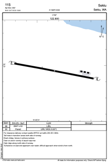
ADC chart of 11S
 Satellite view of 11S

Satellite view of 11S
Sorry, we have no imagery here.
Sorry, we have no imagery here.
Sorry, we have no imagery here.
Sorry, we have no imagery here.
Sorry, we have no imagery here.
Sorry, we have no imagery here.


11S - Sekiu
Located in Sekiu, United States
ICAO - 11S, IATA -
Data provided by AirmateGeneral information
Coordinates: N48°15'58" W124°18'50"
Elevation is 355 feet MSL.
Magnetic variation is 21° East View others Airports in Washington
Operational data
Special qualification required
Current time UTC: 16:14:41
Current local time:
Weather at : KUIL - Quillayute ( 41 km )
METAR: KUIL 281553Z AUTO 23006KT 10SM CLR 17/11 A2988 RMK AO2 SLP119 T01720111
Communications frequencies: [VIEW]
Runways:
| RWY identifier | QFU | Length (ft) | Width (ft) | Surface | LDA (ft) |
| 08 | 0° | 2997 | 50 | ASPH | |
| 26 | 0° | 2997 | 50 | ASPH |
Airport contact information
Address: Sekiu United States
Satellite view of 11S
Sorry, we have no imagery here.
Sorry, we have no imagery here.
Sorry, we have no imagery here.
Sorry, we have no imagery here.
Sorry, we have no imagery here.
Sorry, we have no imagery here.