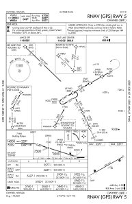
IAC chart of 10U
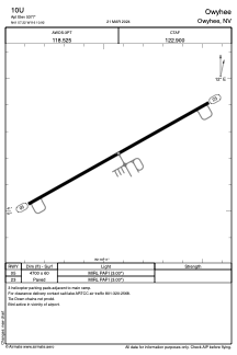
 ADC chart of 10U
 Satellite view of 10U

ADC chart of 10U
Satellite view of 10U
Sorry, we have no imagery here.
Sorry, we have no imagery here.
Sorry, we have no imagery here.
Sorry, we have no imagery here.
Sorry, we have no imagery here.
Sorry, we have no imagery here.


10U - Owyhee
Located in Owyhee, United States
ICAO - 10U, IATA -
Data provided by AirmateGeneral information
Coordinates: N41°57'13" W116°10'55"
Elevation is 5377 feet MSL.
Magnetic variation is 12° East View others Airports in Nevada
Operational data
Special qualification required
Current time UTC: 22:34:19
Current local time:
Weather at : - ( 0 km )
METAR: MMPB 272231Z 05013KT 5SM RA SCT015CB OVC090 16/12 A3029 RMK 8/36/ HZY RAB30
Communications frequencies: [VIEW]
Runways:
| RWY identifier | QFU | Length (ft) | Width (ft) | Surface | LDA (ft) |
| 05 | 61° | 4700 | 60 | ASPH | |
| 23 | 241° | 4700 | 60 | ASPH |
Airport contact information
Address: Owyhee United States
Satellite view of 10U
Sorry, we have no imagery here.
Sorry, we have no imagery here.
Sorry, we have no imagery here.
Sorry, we have no imagery here.
Sorry, we have no imagery here.
Sorry, we have no imagery here.