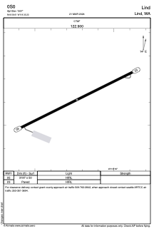
ADC chart of 0S0
 Satellite view of 0S0

Satellite view of 0S0
Sorry, we have no imagery here.
Sorry, we have no imagery here.
Sorry, we have no imagery here.
Sorry, we have no imagery here.
Sorry, we have no imagery here.


0S0 - Lind
Located in Lind, United States
ICAO - 0S0, IATA -
Data provided by AirmateGeneral information
Coordinates: N46°58'37" W118°35'14"
Elevation is 1507 feet MSL.
Magnetic variation is 19° East View others Airports in Washington
Operational data
Special qualification required
Current time UTC: 13:47:38
Current local time:
Weather at : KMWH - Grant County Intl ( 61 km )
METAR: KMWH 221252Z 30003KT 10SM OVC095 11/03 A2997 RMK AO2 SLP148 T01110028
TAF: KMWH 221159Z 2212/2312 36005KT P6SM BKN080 OVC120 FM221900 19007KT P6SM BKN060 FM230200 16006KT P6SM FEW070 FM230500 VRB04KT P6SM SCT200
Communications frequencies: [VIEW]
Runways:
| RWY identifier | QFU | Length (ft) | Width (ft) | Surface | LDA (ft) |
| 05 | 64° | 3197 | 50 | ASPH | |
| 23 | 244° | 3197 | 50 | ASPH |
Airport contact information
Address: Lind United States
Satellite view of 0S0
Sorry, we have no imagery here.
Sorry, we have no imagery here.
Sorry, we have no imagery here.
Sorry, we have no imagery here.
Sorry, we have no imagery here.