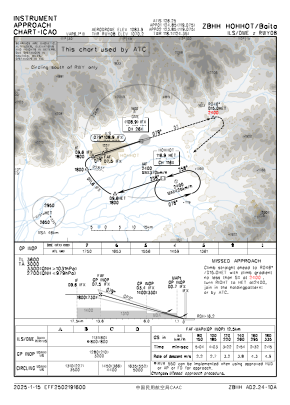
IAC chart of ZBHH
 Satellite view of ZBHH

Satellite view of ZBHH
Sorry, we have no imagery here.
Sorry, we have no imagery here.
Sorry, we have no imagery here.
Sorry, we have no imagery here.
Sorry, we have no imagery here.
Sorry, we have no imagery here.


ZBHH - Hohhot/Baita
Located in Hohhot, China
ICAO - ZBHH, IATA - HET
Data provided by AirmateGeneral information
Coordinates: N40°50'54" E111°49'24"
Elevation is 3556 feet MSL.
View others Airports in Inner Mongolia Autonomous Region
Operational data
Special qualification required
Current time UTC: 18:38:01
Current local time:
Weather
METAR: ZBHH 221800Z VRB01MPS CAVOK 23/17 Q1012 NOSIG
TAF: TAF ZBHH 221501Z 2218/2318 18004MPS 6000 FEW040 TX25/2307Z TN20/2222Z TEMPO 2307/2310 -TSRA SCT040CB SCT040 TEMPO 2307/2312 SHRA TEMPO 2312/2318 RA
Communications frequencies: [VIEW]
Runways:
| RWY identifier | QFU | Length (ft) | Width (ft) | Surface | LDA (ft) |
| 08 | 73° | 11811 | 148 | CON | |
| 26 | 253° | 11811 | 148 | CON |
Airport contact information
Address: Hohhot China
Satellite view of ZBHH
Sorry, we have no imagery here.
Sorry, we have no imagery here.
Sorry, we have no imagery here.
Sorry, we have no imagery here.
Sorry, we have no imagery here.
Sorry, we have no imagery here.