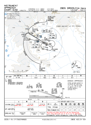
IAC chart of ZBDS
 Satellite view of ZBDS

Satellite view of ZBDS
Sorry, we have no imagery here.
Sorry, we have no imagery here.
Sorry, we have no imagery here.
Sorry, we have no imagery here.
Sorry, we have no imagery here.
Sorry, we have no imagery here.


ZBDS - Ordos/Ejin Horo
Located in Ordos, China
ICAO - ZBDS, IATA - DSN
Data provided by AirmateGeneral information
Coordinates: N39°29'24" E109°51'54"
Elevation is 4593 feet MSL.
View others Airports in Inner Mongolia Autonomous Region
Operational data
Special qualification required
Current time UTC: 04:12:20
Current local time:
Communications frequencies: [VIEW]
Runways:
| RWY identifier | QFU | Length (ft) | Width (ft) | Surface | LDA (ft) |
| 13 | 123° | 10499 | 148 | UNK | |
| 31 | 303° | 10499 | 148 | UNK |
Airport contact information
Address: Ordos China
Satellite view of ZBDS
Sorry, we have no imagery here.
Sorry, we have no imagery here.
Sorry, we have no imagery here.
Sorry, we have no imagery here.
Sorry, we have no imagery here.
Sorry, we have no imagery here.