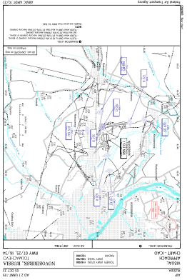
VAC chart of UNNT
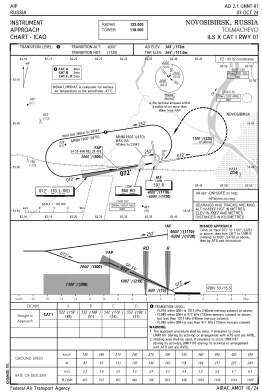
 IAC chart of UNNT
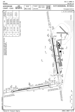
 ADC chart of UNNT
 Satellite view of UNNT

IAC chart of UNNTADC chart of UNNT
Satellite view of UNNT
Sorry, we have no imagery here.
Sorry, we have no imagery here.
Sorry, we have no imagery here.
Sorry, we have no imagery here.
Sorry, we have no imagery here.
Sorry, we have no imagery here.


UNNT - Novosibirsk/Tolmachevo
Located in Novosibirsk, Russian Federation
ICAO - UNNT, IATA - OVB
Data provided by AirmateGeneral information
Coordinates: N55°1'60" E82°35'57"
Elevation is 367 feet MSL.
View others Airports in Novosibirsk Oblast
Operational data
Special qualification required
Current time UTC: 21:57:17
Current local time:
Weather
METAR: UNNT 292130Z 23004MPS CAVOK 09/03 Q1016 R25/090070 R34/090070 NOSIG RMK QFE752/1003
TAF: TAF UNNT 292000Z 2921/3021 24003G08MPS 8000 BKN040CB TX20/3011Z TN05/2923Z BECMG 2923/3003 28007G14MPS BECMG 3014/3016 24003G08MPS
Communications frequencies: [VIEW]
Runways:
| RWY identifier | QFU | Length (ft) | Width (ft) | Surface | LDA (ft) |
| 16 | 170° | 11818 | 148 | ASP | |
| 34 | 350° | 11818 | 148 | ASP | |
| 07 | 81° | 11801 | 197 | ASP | |
| 25 | 261° | 11801 | 197 | ASP |
Airport contact information
Address: Novosibirsk Russian Federation
Satellite view of UNNT
Sorry, we have no imagery here.
Sorry, we have no imagery here.
Sorry, we have no imagery here.
Sorry, we have no imagery here.
Sorry, we have no imagery here.
Sorry, we have no imagery here.