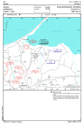
VAC chart of UMKK
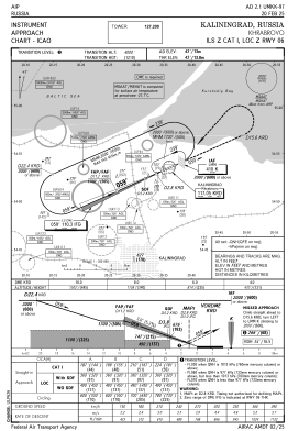
 IAC chart of UMKK
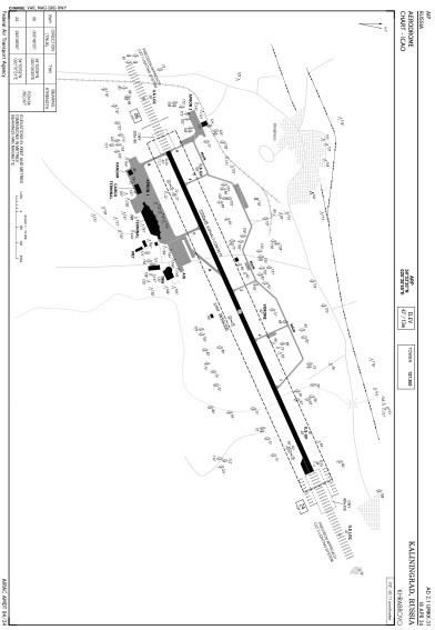
 ADC chart of UMKK
 Satellite view of UMKK
IAC chart of UMKKADC chart of UMKK
Satellite view of UMKK
Sorry, we have no imagery here.
Sorry, we have no imagery here.
Sorry, we have no imagery here.
Sorry, we have no imagery here.
Sorry, we have no imagery here.
Sorry, we have no imagery here.


UMKK - Kaliningrad/Khrabrovo
Located in Kaliningrad, Russian Federation
ICAO - UMKK, IATA - KGD
Data provided by AirmateGeneral information
Coordinates: N54°53'30" E20°35'55"
Elevation is 42 feet MSL.
View others Airports in Kaliningrad Oblast
Operational data
Special qualification required
Current time UTC: 19:54:35
Current local time:
Weather
METAR: UMKK 231930Z 13002MPS CAVOK 07/05 Q1015 R24/CLRD95 NOSIG RMK QFE760/1013
TAF: TAF UMKK 231655Z 2318/2418 VRB01MPS 6000 BKN016 TEMPO 2400/2403 1000 MIFG BR BECMG 2405/2407 22003MPS BECMG 2410/2412 33003G08MPS TEMPO 2412/2418 01003G10MPS
Communications frequencies: [VIEW]
Runways:
| RWY identifier | QFU | Length (ft) | Width (ft) | Surface | LDA (ft) |
| 06 | 66° | 10991 | 148 | CON | |
| 24 | 246° | 10991 | 148 | CON |
Airport contact information
Address: Kaliningrad Russian Federation
Satellite view of UMKK
Sorry, we have no imagery here.
Sorry, we have no imagery here.
Sorry, we have no imagery here.
Sorry, we have no imagery here.
Sorry, we have no imagery here.
Sorry, we have no imagery here.