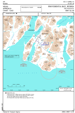
VAC chart of UHMD
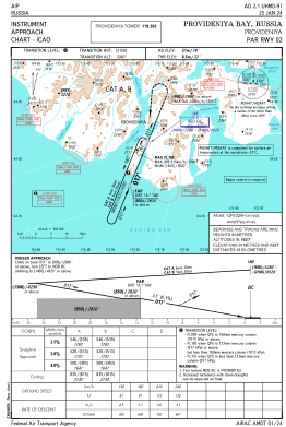
 IAC chart of UHMD
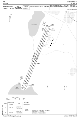
 ADC chart of UHMD
 Satellite view of UHMD

IAC chart of UHMDADC chart of UHMD
Satellite view of UHMD
Sorry, we have no imagery here.
Sorry, we have no imagery here.
Sorry, we have no imagery here.
Sorry, we have no imagery here.
Sorry, we have no imagery here.
Sorry, we have no imagery here.


UHMD - Provideniya Bay
Located in Provideniya, Russian Federation
ICAO - UHMD, IATA - PVS
Data provided by AirmateGeneral information
Coordinates: N64°22'44" W173°14'33"
Elevation is 71 feet MSL.
View others Airports in Chukotka Autonomous Okrug
Operational data
Special qualification required
Current time UTC: 02:34:27
Current local time:
Weather
METAR: UHMD 260230Z 03009MPS 9999 SCT040 OVC080 07/M02 Q1002 RMK QFE751/1001
TAF: TAF UHMD 260151Z 2603/2609 03008G13MPS 9999 BKN030 TEMPO 2603/2609 5000 BR SCT015
Communications frequencies: [VIEW]
Runways:
| RWY identifier | QFU | Length (ft) | Width (ft) | Surface | LDA (ft) |
| 02 | 21° | 6562 | 171 | UNK | |
| 20 | 202° | 6562 | 171 | UNK |
Airport contact information
Address: Provideniya Russian Federation
Satellite view of UHMD
Sorry, we have no imagery here.
Sorry, we have no imagery here.
Sorry, we have no imagery here.
Sorry, we have no imagery here.
Sorry, we have no imagery here.
Sorry, we have no imagery here.