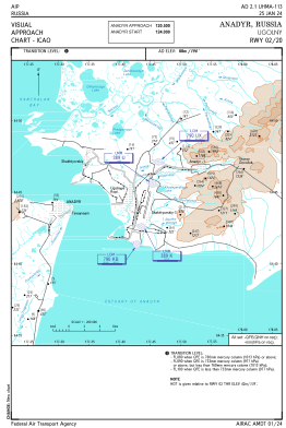
VAC chart of UHMA
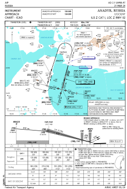
 IAC chart of UHMA
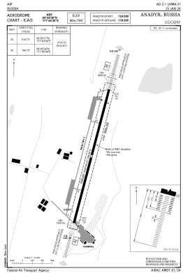
 ADC chart of UHMA
 Satellite view of UHMA

IAC chart of UHMAADC chart of UHMA
Satellite view of UHMA
Sorry, we have no imagery here.
Sorry, we have no imagery here.
Sorry, we have no imagery here.
Sorry, we have no imagery here.
Sorry, we have no imagery here.
Sorry, we have no imagery here.


UHMA - Anadyr/Ugolny
Located in Anadyr, Russian Federation
ICAO - UHMA, IATA - DYR
Data provided by AirmateGeneral information
Coordinates: N64°44'6" E177°44'30"
Elevation is 194 feet MSL.
View others Airports in Chukotka Autonomous Okrug
Operational data
Special qualification required
Current time UTC: 17:31:09
Current local time:
Weather
METAR: UHMA 251700Z 35004MPS 9999 FEW040 M00/M01 Q1005 R02/////// NOSIG RMK MID 33003MPS END R02/35003MPS QFE750/1000
TAF: TAF UHMA 251650Z 2518/2618 31003MPS 9999 FEW002 TEMPO 2600/2618 15005MPS 0300 FG BKN002
Communications frequencies: [VIEW]
Runways:
| RWY identifier | QFU | Length (ft) | Width (ft) | Surface | LDA (ft) |
| 02 | 15° | 11483 | 197 | UNK | |
| 20 | 195° | 11483 | 197 | UNK |
Airport contact information
Address: Anadyr Russian Federation
Satellite view of UHMA
Sorry, we have no imagery here.
Sorry, we have no imagery here.
Sorry, we have no imagery here.
Sorry, we have no imagery here.
Sorry, we have no imagery here.
Sorry, we have no imagery here.