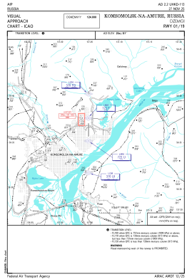
VAC chart of UHKD
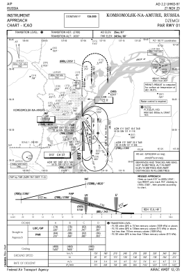
 IAC chart of UHKD
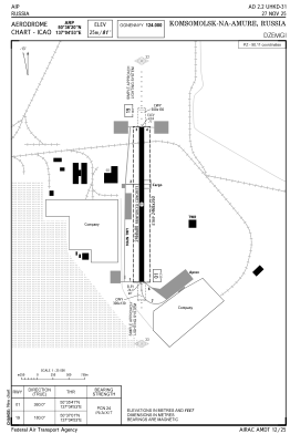
 ADC chart of UHKD
 Satellite view of UHKD

IAC chart of UHKDADC chart of UHKD
Satellite view of UHKD
Sorry, we have no imagery here.
Sorry, we have no imagery here.
Sorry, we have no imagery here.
Sorry, we have no imagery here.
Sorry, we have no imagery here.
Sorry, we have no imagery here.


UHKD - Komsomolsk-Na-Amure/Dzemgi
Located in Komsomolsk-Na-Amure, Russian Federation
ICAO - UHKD, IATA -
Data provided by AirmateGeneral information
Coordinates: N50°36'20" E137°4'53"
Elevation is 82 feet MSL.
View others Airports in Khabarovsk Krai
Operational data
Special qualification required
Current time UTC: 22:25:38
Current local time:
Communications frequencies: [VIEW]
Runways:
| RWY identifier | QFU | Length (ft) | Width (ft) | Surface | LDA (ft) |
| 01 | 360° | 8097 | 262 | UNK | |
| 19 | 180° | 8097 | 262 | UNK |
Airport contact information
Address: Komsomolsk-Na-Amure Russian Federation
Satellite view of UHKD
Sorry, we have no imagery here.
Sorry, we have no imagery here.
Sorry, we have no imagery here.
Sorry, we have no imagery here.
Sorry, we have no imagery here.
Sorry, we have no imagery here.