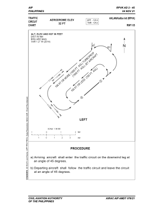
VAC chart of RPVK
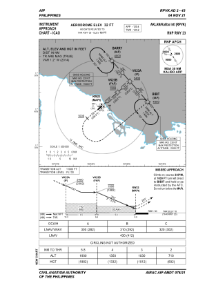
 IAC chart of RPVK
 ADC chart of RPVK
 Satellite view of RPVK

IAC chart of RPVKADC chart of RPVK
Satellite view of RPVK
Sorry, we have no imagery here.
Sorry, we have no imagery here.
Sorry, we have no imagery here.
Sorry, we have no imagery here.
Sorry, we have no imagery here.
Sorry, we have no imagery here.


RPVK - Kalibo International Airport
Located in , Philippines
ICAO - RPVK, IATA - KLO
Data provided by AirmateGeneral information
Coordinates: N11°40'46" E122°22'31"
Elevation is 32 feet MSL.
Magnetic variation is -2° East View others Airports in Aklan
Operational data
Special qualification required
Current time UTC: 10:47:10
Current local time:
Weather
METAR: RPVK 111000Z 09002KT 9999 FEW013TCU SCT070 BKN240 29/25 Q1009 RMK A2980 TCU NE,W
TAF: TAF RPVK 110500Z 1106/1206 06007KT 9999 FEW016 SCT070 TEMPO 1106/1112 VRB07KT -TSRA FEW013CB SCT016 BKN070 TEMPO 1200/1206 5000 SHRA FEW013CB SCT016 BKN070
Communications frequencies: [VIEW]
Runways:
| RWY identifier | QFU | Length (ft) | Width (ft) | Surface | LDA (ft) |
| 05 | 49° | 8202 | 148 | CONC+ASPH | 8202 |
| 23 | 229° | 8202 | 148 | CONC+ASPH | 8202 |
Airport contact information
Address: Philippines
Satellite view of RPVK
Sorry, we have no imagery here.
Sorry, we have no imagery here.
Sorry, we have no imagery here.
Sorry, we have no imagery here.
Sorry, we have no imagery here.
Sorry, we have no imagery here.