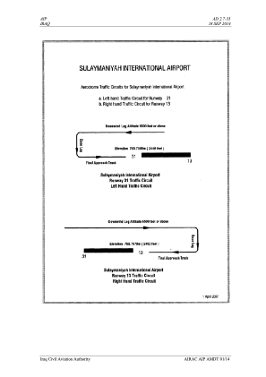
VAC chart of ORSU
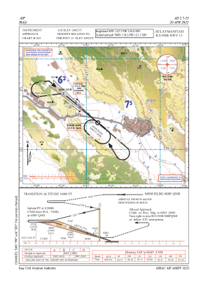
 IAC chart of ORSU
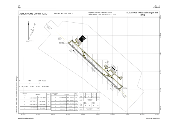
 ADC chart of ORSU
 Satellite view of ORSU

IAC chart of ORSUADC chart of ORSU
Satellite view of ORSU
Sorry, we have no imagery here.
Sorry, we have no imagery here.
Sorry, we have no imagery here.
Sorry, we have no imagery here.
Sorry, we have no imagery here.
Sorry, we have no imagery here.


ORSU - Sulaymaniyah International Airport
Located in Sulaymaniyah, Iraq
ICAO - ORSU, IATA - ISU
Data provided by AirmateGeneral information
Coordinates: N35°33'38" E45°18'52"
Elevation is 2492 feet MSL.
View others Airports in As-Sulaymaniyyah Governorate
Operational data
Special qualification required
Current time UTC: 11:55:19
Current local time:
Weather
METAR: ORSU 251100Z 02010KT 9999 FEW045 36/04 Q1008
TAF: TAF ORSU 251100Z 2512/2612 06015KT 9999 SCT045 BECMG 2523/2601 G25KT CAVOK
Communications frequencies: [VIEW]
Runways:
| RWY identifier | QFU | Length (ft) | Width (ft) | Surface | LDA (ft) |
| 13 | 133° | 11483 | 148 | CON | |
| 31 | 313° | 11483 | 148 | CON |
Airport contact information
Address: Sulaymaniyah Iraq
Satellite view of ORSU
Sorry, we have no imagery here.
Sorry, we have no imagery here.
Sorry, we have no imagery here.
Sorry, we have no imagery here.
Sorry, we have no imagery here.
Sorry, we have no imagery here.