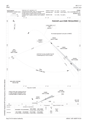
IAC chart of ORMM
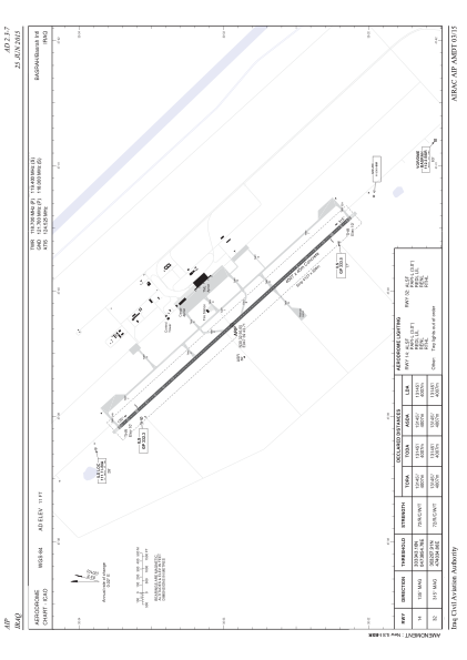
 ADC chart of ORMM
 Satellite view of ORMM

ADC chart of ORMM
Satellite view of ORMM
Sorry, we have no imagery here.
Sorry, we have no imagery here.
Sorry, we have no imagery here.
Sorry, we have no imagery here.
Sorry, we have no imagery here.
Sorry, we have no imagery here.


ORMM - Basrah International Airport
Located in Basrah, Iraq
ICAO - ORMM, IATA - BSR
Data provided by AirmateGeneral information
Coordinates: N30°32'56" E47°39'43"
Elevation is 11 feet MSL.
View others Airports in Basra Governorate
Operational data
Special qualification required
Current time UTC: 14:48:46
Current local time:
Weather
METAR: ORMM 231400Z 32008KT 9999 SCT030 SCT100 46/M02 Q0997
TAF: TAF ORMM 231000Z 2312/2412 32016KT 8000 FEW040 SCT100
Communications frequencies: [VIEW]
Runways:
| RWY identifier | QFU | Length (ft) | Width (ft) | Surface | LDA (ft) |
| 14 | 138° | 13146 | 148 | CON | |
| 32 | 318° | 13146 | 148 | CON |
Airport contact information
Address: Basrah Iraq
Satellite view of ORMM
Sorry, we have no imagery here.
Sorry, we have no imagery here.
Sorry, we have no imagery here.
Sorry, we have no imagery here.
Sorry, we have no imagery here.
Sorry, we have no imagery here.