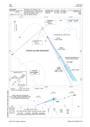
IAC chart of ORBI
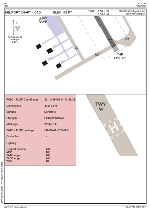
 ADC chart of ORBI
 Satellite view of ORBI

ADC chart of ORBI
Satellite view of ORBI
Sorry, we have no imagery here.
Sorry, we have no imagery here.
Sorry, we have no imagery here.
Sorry, we have no imagery here.
Sorry, we have no imagery here.
Sorry, we have no imagery here.


ORBI - Baghdad International Airport
Located in Baghdad, Iraq
ICAO - ORBI, IATA - BGW
Data provided by AirmateGeneral information
Coordinates: N33°15'45" E44°14'4"
Elevation is 114 feet MSL.
View others Airports in Baghdad Governorate
Operational data
Special qualification required
Current time UTC: 20:14:45
Current local time:
Weather
TAF: TAF ORBI 301700Z 3018/3118 32006KT CAVOK BECMG 3106/3108 30016KT 8000 NSC
Communications frequencies: [VIEW]
Runways:
| RWY identifier | QFU | Length (ft) | Width (ft) | Surface | LDA (ft) |
| 15R | 150° | 10830 | 148 | CON | |
| 33L | 330° | 10830 | 148 | CON | |
| 15L | 150° | 13123 | 197 | CON | |
| 33R | 330° | 13123 | 197 | CON |
Airport contact information
Address: Baghdad Iraq
Satellite view of ORBI
Sorry, we have no imagery here.
Sorry, we have no imagery here.
Sorry, we have no imagery here.
Sorry, we have no imagery here.
Sorry, we have no imagery here.
Sorry, we have no imagery here.