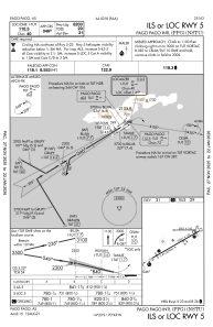
IAC chart of NSTU
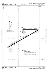
 ADC chart of NSTU
 Satellite view of NSTU

ADC chart of NSTU
Satellite view of NSTU
Sorry, we have no imagery here.
Sorry, we have no imagery here.
Sorry, we have no imagery here.
Sorry, we have no imagery here.
Sorry, we have no imagery here.
Sorry, we have no imagery here.


NSTU - Pago Pago Intl
Located in Pago Pago, Samoa
ICAO - PPG, IATA - PPG
Data provided by AirmateGeneral information
Coordinates: S14°19'54" W170°42'41"
Elevation is 31 feet MSL.
Magnetic variation is 12° East View others Airports in (unassigned)
Operational data
Special qualification required
Current time UTC: 10:24:43
Current local time:
Weather
METAR: NSTU 220950Z VRB02KT 10SM SCT017 OVC100 25/23 A2985 RMK SLP108 T02500233
TAF: NSTU 220955Z 2210/2306 VRB06KT P6SM VCSH SCT015 BKN040 FM221200 11014KT P6SM VCSH SCT015 BKN040
Communications frequencies: [VIEW]
Runways:
| RWY identifier | QFU | Length (ft) | Width (ft) | Surface | LDA (ft) |
| 05 | 60° | 10001 | 150 | ASPH | 8200 |
| 23 | 240° | 10001 | 150 | ASPH | 9200 |
| 08 | 90° | 3801 | 100 | ASPH | |
| 26 | 270° | 3801 | 100 | ASPH |
Airport contact information
Address: Pago Pago Samoa
Satellite view of NSTU
Sorry, we have no imagery here.
Sorry, we have no imagery here.
Sorry, we have no imagery here.
Sorry, we have no imagery here.
Sorry, we have no imagery here.
Sorry, we have no imagery here.