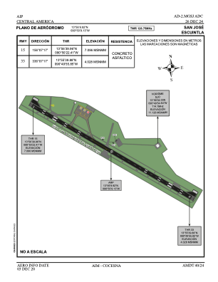
ADC chart of MGSJ
 Satellite view of MGSJ

Satellite view of MGSJ
Sorry, we have no imagery here.
Sorry, we have no imagery here.
Sorry, we have no imagery here.
Sorry, we have no imagery here.
Sorry, we have no imagery here.
Sorry, we have no imagery here.


MGSJ - San Jose Escuintla
Located in Escuintla, Guatemala
ICAO - MGSJ, IATA - GSJ
Data provided by AirmateGeneral information
Coordinates: N13°56'10" W90°50'9"
Elevation is 17 feet MSL.
Magnetic variation is 1° East View others Airports in Escuintla
Operational data
Special qualification required
Current time UTC: 23:06:43
Current local time:
Weather at : MGGT - La Aurora ( 79 km )
METAR: MGGT 242300Z 15004KT 9999 FEW022 SCT090 22/17 Q1021 A3015 RMK FEW200
TAF: MGGT 242300Z 2500/2524 18008KT 9999 SCT016 TX28/2520Z TN18/2512Z ECMG 2502/2504 00000KT SCT016 BECMG 2506/2508 03008KT FEW020
Communications frequencies: [VIEW]
Runways:
| RWY identifier | QFU | Length (ft) | Width (ft) | Surface | LDA (ft) |
| 15 | 157° | 6620 | 138 | ASPH | |
| 33 | 337° | 6620 | 138 | ASPH |
Airport contact information
Address: Escuintla Guatemala
Satellite view of MGSJ
Sorry, we have no imagery here.
Sorry, we have no imagery here.
Sorry, we have no imagery here.
Sorry, we have no imagery here.
Sorry, we have no imagery here.
Sorry, we have no imagery here.