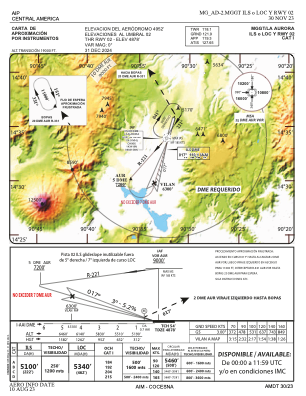
IAC chart of MGGT
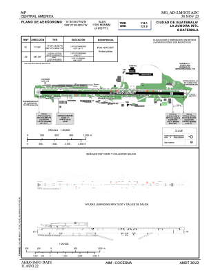
 ADC chart of MGGT
 Satellite view of MGGT

ADC chart of MGGT
Satellite view of MGGT
Sorry, we have no imagery here.
Sorry, we have no imagery here.
Sorry, we have no imagery here.
Sorry, we have no imagery here.
Sorry, we have no imagery here.
Sorry, we have no imagery here.


MGGT - La Aurora
Located in Guatemala, Guatemala
ICAO - MGGT, IATA - GUA
Data provided by AirmateGeneral information
Coordinates: N14°35'0" W90°31'39"
Elevation is 4952 feet MSL.
View others Airports in Guatemala
Operational data
Special qualification required
Current time UTC: 21:23:45
Current local time:
Weather
METAR: MGGT 252100Z 02010KT 9999 SCT022 FEW025CB 28/14 Q1021 A3015 RMK CB/PCPN S
TAF: MGGT 251700Z 2518/2618 04008KT 9999 SCT018 SCT090 TX28/2520Z TN17/2612Z PROB40 TEMPO 2518/2606 18008KT 8000 VCTSRA SCT020TCU FEW025CB BECMG 2600/2602 SCT016 TEMPO 2606/2616 VRB03KT 5000 BR BKN012 BECMG 2616/2618 SCT018
Communications frequencies: [VIEW]
Runways:
| RWY identifier | QFU | Length (ft) | Width (ft) | Surface | LDA (ft) |
| 02 | 17° | 9800 | 197 | UNK | |
| 20 | 197° | 9800 | 197 | UNK |
Airport contact information
Address: Guatemala Guatemala
Satellite view of MGGT
Sorry, we have no imagery here.
Sorry, we have no imagery here.
Sorry, we have no imagery here.
Sorry, we have no imagery here.
Sorry, we have no imagery here.
Sorry, we have no imagery here.