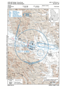
VAC chart of LYTR
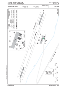
 ADC chart of LYTR
 Satellite view of LYTR

ADC chart of LYTR
Satellite view of LYTR
Sorry, we have no imagery here.
Sorry, we have no imagery here.
Sorry, we have no imagery here.
Sorry, we have no imagery here.
Sorry, we have no imagery here.
Sorry, we have no imagery here.


LYTR - Trstenik
Located in , Serbia and Montenegro
ICAO - LYTR, IATA -
Data provided by AirmateGeneral information
Coordinates: N43°36'51" E21°1'49"
Elevation is 534 feet MSL.
Magnetic variation is 5° East View others Airports in Rasina
Operational data
Special qualification required
Current time UTC: 11:11:36
Current local time:
Weather at : LYKV - Kraljevo / Morava ( 42 km )
TAF: TAF LYKV 130500Z 1306/1406 02004KT CAVOK TX35/1314Z TN15/1404Z TEMPO 1310/1316 09010KT
Communications frequencies: [VIEW]
Runways:
| RWY identifier | QFU | Length (ft) | Width (ft) | Surface | LDA (ft) |
| 11 | 0° | 5161 | 262 | UNK | |
| 29 | 0° | 5161 | 262 | UNK |
Airport contact information
Address: Serbia and Montenegro
Satellite view of LYTR
Sorry, we have no imagery here.
Sorry, we have no imagery here.
Sorry, we have no imagery here.
Sorry, we have no imagery here.
Sorry, we have no imagery here.
Sorry, we have no imagery here.