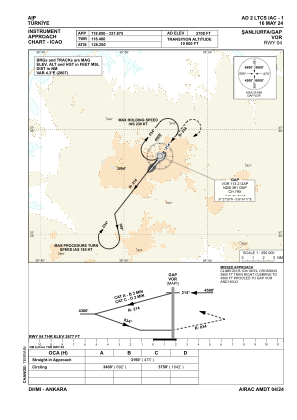
IAC chart of LTCS
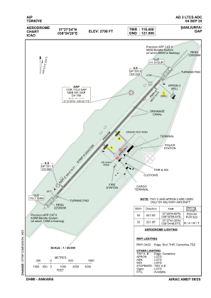
 ADC chart of LTCS
 Satellite view of LTCS

ADC chart of LTCS
Satellite view of LTCS
Sorry, we have no imagery here.
Sorry, we have no imagery here.
Sorry, we have no imagery here.
Sorry, we have no imagery here.
Sorry, we have no imagery here.
Sorry, we have no imagery here.


LTCS - Sanliurfa Gap
Located in Sanliurfa, Turkey
ICAO - LTCS, IATA - GNY
Data provided by AirmateGeneral information
Coordinates: N37°27'24" E38°54'29"
Elevation is 2708 feet MSL.
Magnetic variation is 5.5° East View others Airports in Sanliurfa
Operational data
Special qualification required
Current time UTC: 09:16:11
Current local time:
Weather
METAR: LTCS 140850Z 01012KT CAVOK 37/01 Q1012 RMK RWY22 35011KT 320V050 SKC
TAF: TAF LTCS 140440Z 1406/1506 05012KT CAVOK
Communications frequencies: [VIEW]
Runways:
| RWY identifier | QFU | Length (ft) | Width (ft) | Surface | LDA (ft) |
| 04 | 42° | 13123 | 148 | CONC | 13123 |
| 22 | 222° | 13123 | 148 | CONC | 13123 |
Airport contact information
Address: Sanliurfa Turkey
Satellite view of LTCS
Sorry, we have no imagery here.
Sorry, we have no imagery here.
Sorry, we have no imagery here.
Sorry, we have no imagery here.
Sorry, we have no imagery here.
Sorry, we have no imagery here.