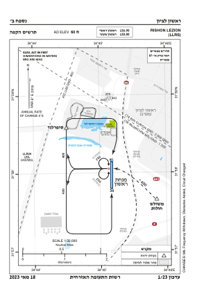
VAC chart of LLRS
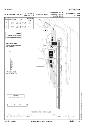
 ADC chart of LLRS
 Satellite view of LLRS

ADC chart of LLRS
Satellite view of LLRS
Sorry, we have no imagery here.
Sorry, we have no imagery here.
Sorry, we have no imagery here.
Sorry, we have no imagery here.
Sorry, we have no imagery here.
Sorry, we have no imagery here.


LLRS - Rishon Lezion
Located in ראשל"צ, Israel
ICAO - , IATA - RLZ
Data provided by AirmateGeneral information
Coordinates: N31°58'3" E34°45'13"
Elevation is 60 feet MSL.
Magnetic variation is 5° East View others Airports in Center District
Operational data
Special qualification required
Current time UTC: 13:03:27
Current local time:
Weather at : LLBG - Tel-Aviv/Ben-Gurion ( 13 km )
METAR: LLBG 251250Z 28008KT CAVOK 30/13 Q1009 NOSIG
TAF: TAF LLBG 251104Z 2512/2612 30010KT CAVOK BECMG 2515/2517 VRB04KT PROB30 TEMPO 2600/2606 3000 BR SCT005 BECMG 2607/2609 29010KT TX31/2512Z TN20/2603Z
Communications frequencies: [VIEW]
Runways:
| RWY identifier | QFU | Length (ft) | Width (ft) | Surface | LDA (ft) |
| 18 | 0° | 2165 | 30 | UNK | |
| 33 | 0° | 2165 | 30 | UNK | |
| 36 | 0° | 0 | 0 | UNK | |
| 36 | 360° | 0 | 0 | UNK | |
| 18 | 180° | 0 | 0 | UNK |
Airport contact information
Address: ראשל"צ Israel
Satellite view of LLRS
Sorry, we have no imagery here.
Sorry, we have no imagery here.
Sorry, we have no imagery here.
Sorry, we have no imagery here.
Sorry, we have no imagery here.
Sorry, we have no imagery here.