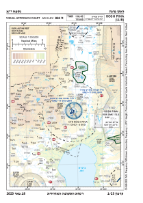
VAC chart of LLIB
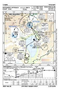
 IAC chart of LLIB
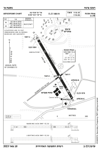
 ADC chart of LLIB
 Satellite view of LLIB

IAC chart of LLIBADC chart of LLIB
Satellite view of LLIB
Sorry, we have no imagery here.
Sorry, we have no imagery here.
Sorry, we have no imagery here.
Sorry, we have no imagery here.
Sorry, we have no imagery here.
Sorry, we have no imagery here.


LLIB - Rosh Pina
Located in Mahanayim, Israel
ICAO - LLIB, IATA - RPN
Data provided by AirmateGeneral information
Coordinates: N32°58'52" E35°34'15"
Elevation is 884 feet MSL.
Magnetic variation is 5° East View others Airports in North District
Operational data
Special qualification required
Current time UTC: 13:27:07
Current local time:
Weather
METAR: LLIB 221250Z AUTO 01009KT 320V050 CAVOK 34/13 Q1008
TAF: TAF LLIB 221100Z 2212/2312 18007KT CAVOK BECMG 2213/2215 34012KT BECMG 2217/2219 VRB03KT BECMG 2306/2308 24010KT TX34/2212Z TN15/2303Z
Communications frequencies: [VIEW]
Runways:
| RWY identifier | QFU | Length (ft) | Width (ft) | Surface | LDA (ft) |
| 15 | 150° | 3625 | 98 | ASPH | 3543 |
| 33 | 330° | 3625 | 98 | ASPH | 3307 |
Airport contact information
Address: Mahanayim Israel
Satellite view of LLIB
Sorry, we have no imagery here.
Sorry, we have no imagery here.
Sorry, we have no imagery here.
Sorry, we have no imagery here.
Sorry, we have no imagery here.
Sorry, we have no imagery here.