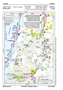
VAC chart of LLHZ
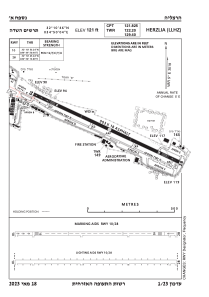
 ADC chart of LLHZ
 Satellite view of LLHZ

ADC chart of LLHZ
Satellite view of LLHZ
Sorry, we have no imagery here.
Sorry, we have no imagery here.
Sorry, we have no imagery here.
Sorry, we have no imagery here.
Sorry, we have no imagery here.
Sorry, we have no imagery here.


LLHZ - Herzelia Domestic Airport
Located in Herzelia, Israel
ICAO - LLHZ, IATA - HRZ
Data provided by AirmateGeneral information
Coordinates: N32°10'50" E34°50'5"
Elevation is 121 feet MSL.
Magnetic variation is 5° East View others Airports in Tel Aviv District
Operational data
Special qualification required
Current time UTC: 08:06:02
Current local time:
Weather
TAF: TAF LLHZ 220513Z 2206/2306 VRB03KT 9999 SCT022 BECMG 2207/2209 30010KT FEW025 BECMG 2215/2217 VRB03KT FEW018 BECMG 2221/2223 17005KT SCT017 PROB40 2301/2305 BKN015 TX25/2211Z TN18/2303Z
Communications frequencies: [VIEW]
Runways:
| RWY identifier | QFU | Length (ft) | Width (ft) | Surface | LDA (ft) |
| 10 | 0° | 2963 | 59 | ASPH | |
| 28 | 0° | 2963 | 59 | ASPH |
Airport contact information
Address: Herzelia Israel
