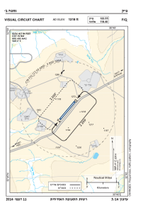
VAC chart of LLFK
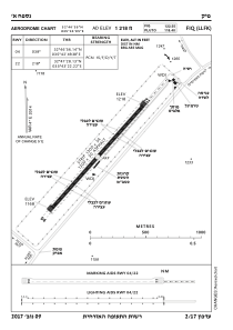
 ADC chart of LLFK
 Satellite view of LLFK
ADC chart of LLFK
Satellite view of LLFK
Sorry, we have no imagery here.
Sorry, we have no imagery here.
Sorry, we have no imagery here.
Sorry, we have no imagery here.
Sorry, we have no imagery here.
Sorry, we have no imagery here.


LLFK - Fik Airstrip
Located in Afik, Israel
ICAO - LLFK, IATA - FIK
Data provided by AirmateGeneral information
Coordinates: N32°47'11" E35°43'2"
Elevation is 1218 feet MSL.
Magnetic variation is 5° East View others Airports in North District
Operational data
Special qualification required
Current time UTC: 14:26:59
Current local time:
Weather at : LLIB - Rosh Pina ( 26 km )
METAR: LLIB 231350Z AUTO 32010KT 280V350 CAVOK 31/08 Q1009
TAF: TAF LLIB 231103Z 2312/2412 32012KT CAVOK BECMG 2316/2318 VRB04KT PROB40 TEMPO 2400/2406 2000 BR BKN008 BECMG 2406/2407 19005KT TX30/2312Z TN17/2404Z
Communications frequencies: [VIEW]
Runways:
| RWY identifier | QFU | Length (ft) | Width (ft) | Surface | LDA (ft) |
| 04 | 41° | 4259 | 112 | ASPH | |
| 22 | 221° | 4259 | 112 | ASPH |
Airport contact information
Address: Afik Israel
Satellite view of LLFK
Sorry, we have no imagery here.
Sorry, we have no imagery here.
Sorry, we have no imagery here.
Sorry, we have no imagery here.
Sorry, we have no imagery here.
Sorry, we have no imagery here.