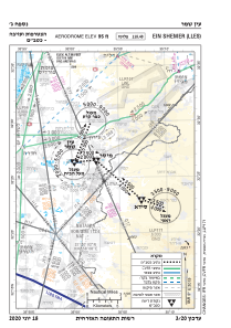
VAC chart of LLES
 Satellite view of LLES

Satellite view of LLES
Sorry, we have no imagery here.
Sorry, we have no imagery here.
Sorry, we have no imagery here.
Sorry, we have no imagery here.
Sorry, we have no imagery here.


LLES - Ein Shemer
Located in Ein Shemer, Israel
ICAO - LLES, IATA -
Data provided by AirmateGeneral information
Coordinates: N32°26'27" E35°0'12"
Elevation is 95 feet MSL.
Magnetic variation is 5° East View others Airports in North District
Operational data
Special qualification required
Current time UTC: 00:30:48
Current local time:
Weather at : LLHZ - Herzelia Domestic Airport ( 33 km )
TAF: TAF LLHZ 222303Z 2300/2324 VRB04KT 9999 SCT020 PROB40 TEMPO 2300/2305 17005KT BKN013 BECMG 2307/2309 25010KT CAVOK BECMG 2315/2317 VRB04KT PROB30 TEMPO 2317/2324 19006KT 9999 SCT017 TX25/2312Z TN18/2303Z
Communications frequencies: [VIEW]
Runways:
| RWY identifier | QFU | Length (ft) | Width (ft) | Surface | LDA (ft) |
| 10 | 97° | 4265 | 92 | UNK | |
| 28 | 277° | 4265 | 92 | UNK | |
| 10 | 0° | 0 | 0 | UNK | |
| 28 | 0° | 0 | 0 | UNK |
Airport contact information
Address: Ein Shemer Israel
Satellite view of LLES
Sorry, we have no imagery here.
Sorry, we have no imagery here.
Sorry, we have no imagery here.
Sorry, we have no imagery here.
Sorry, we have no imagery here.