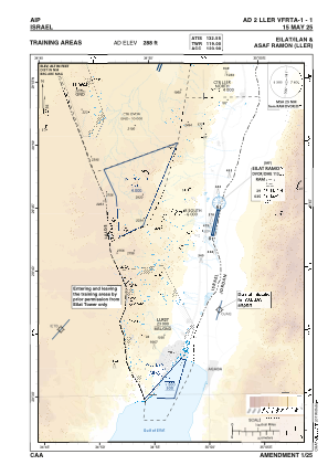
VAC chart of LLER
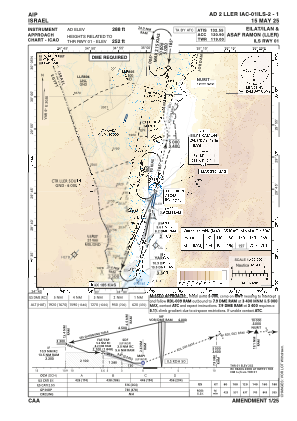
 IAC chart of LLER
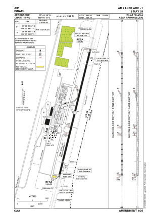
 ADC chart of LLER
 Satellite view of LLER
IAC chart of LLERADC chart of LLER
Satellite view of LLER
Sorry, we have no imagery here.
Sorry, we have no imagery here.
Sorry, we have no imagery here.
Sorry, we have no imagery here.
Sorry, we have no imagery here.
Sorry, we have no imagery here.


LLER - Eilat/ Ilan And Asaf Ramon
Located in Eilat, Israel
ICAO - , IATA - ETM
Data provided by AirmateGeneral information
Coordinates: N29°43'38" E35°0'51"
Elevation is 288 feet MSL.
Magnetic variation is 5° East View others Airports in South District
Operational data
Special qualification required
Current time UTC: 02:34:29
Current local time:
Weather
METAR: LLER 260150Z AUTO 35010KT CAVOK 26/09 Q1007
TAF: TAF LLER 252310Z 2600/2624 36012KT CAVOK BECMG 2607/2609 17010KT TEMPO 2614/2619 VRB04KT BECMG 2619/2621 36010KT TX44/2612Z TN25/2603Z
Communications frequencies: [VIEW]
Runways:
| RWY identifier | QFU | Length (ft) | Width (ft) | Surface | LDA (ft) |
| 01 | 14° | 11811 | 148 | ASPH | 11811 |
| 19 | 194° | 11811 | 148 | ASPH | 11811 |
Airport contact information
Address: Eilat Israel
Satellite view of LLER
Sorry, we have no imagery here.
Sorry, we have no imagery here.
Sorry, we have no imagery here.
Sorry, we have no imagery here.
Sorry, we have no imagery here.
Sorry, we have no imagery here.