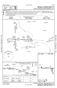
IAC chart of KVTI
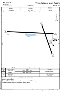
 ADC chart of KVTI
 Satellite view of KVTI
ADC chart of KVTI
Satellite view of KVTI
Sorry, we have no imagery here.
Sorry, we have no imagery here.
Sorry, we have no imagery here.
Sorry, we have no imagery here.
Sorry, we have no imagery here.
Sorry, we have no imagery here.


KVTI - Vinton Veterans Meml Airpark
Located in Vinton, United States
ICAO - VTI, IATA -
Data provided by AirmateGeneral information
Coordinates: N42°13'7" W92°1'33"
Elevation is 842 feet MSL.
Magnetic variation is 01° East View others Airports in Iowa
Operational data
Special qualification required
Current time UTC: 02:10:31
Current local time:
Weather
METAR: KVTI 040135Z AUTO 13010KT 10SM BKN050 BKN060 11/03 A2971 RMK AO2 T01100031
Communications frequencies: [VIEW]
Runways:
| RWY identifier | QFU | Length (ft) | Width (ft) | Surface | LDA (ft) |
| 09 | 92° | 4000 | 60 | CONC | |
| 27 | 273° | 4000 | 60 | CONC | |
| 16 | 161° | 2500 | 50 | ASPH | |
| 34 | 341° | 2500 | 50 | ASPH |
Airport contact information
Address: Vinton United States
Satellite view of KVTI
Sorry, we have no imagery here.
Sorry, we have no imagery here.
Sorry, we have no imagery here.
Sorry, we have no imagery here.
Sorry, we have no imagery here.
Sorry, we have no imagery here.