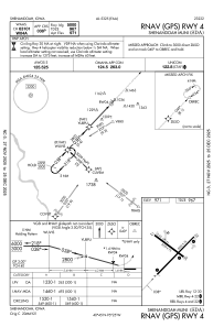
IAC chart of KSDA
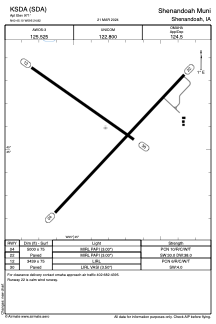
 ADC chart of KSDA
 Satellite view of KSDA
ADC chart of KSDA
Satellite view of KSDA
Sorry, we have no imagery here.
Sorry, we have no imagery here.
Sorry, we have no imagery here.
Sorry, we have no imagery here.
Sorry, we have no imagery here.
Sorry, we have no imagery here.


KSDA - Shenandoah Muni
Located in Shenandoah, United States
ICAO - SDA, IATA -
Data provided by AirmateGeneral information
Coordinates: N40°45'6" W95°24'49"
Elevation is 971 feet MSL.
Magnetic variation is 05° East View others Airports in Iowa
Operational data
Special qualification required
Current time UTC: 02:00:41
Current local time:
Weather
METAR: KSDA 040135Z AUTO 30007G22KT 290V350 10SM FEW060 FEW100 SCT120 13/07 A2951 RMK AO2
Communications frequencies: [VIEW]
Runways:
| RWY identifier | QFU | Length (ft) | Width (ft) | Surface | LDA (ft) |
| 04 | 43° | 5000 | 75 | CONC | |
| 22 | 223° | 5000 | 75 | CONC | |
| 12 | 125° | 3439 | 75 | CONC | |
| 30 | 305° | 3439 | 75 | CONC |
Airport contact information
Address: Shenandoah United States
Satellite view of KSDA
Sorry, we have no imagery here.
Sorry, we have no imagery here.
Sorry, we have no imagery here.
Sorry, we have no imagery here.
Sorry, we have no imagery here.
Sorry, we have no imagery here.