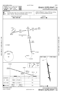
IAC chart of KRRQ
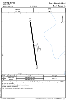
 ADC chart of KRRQ
 Satellite view of KRRQ

ADC chart of KRRQ
Satellite view of KRRQ
Sorry, we have no imagery here.
Sorry, we have no imagery here.
Sorry, we have no imagery here.
Sorry, we have no imagery here.
Sorry, we have no imagery here.
Sorry, we have no imagery here.


KRRQ - Rock Rapids Muni
Located in Rock Rapids, United States
ICAO - RRQ, IATA -
Data provided by AirmateGeneral information
Coordinates: N43°27'8" W96°10'47"
Elevation is 1363 feet MSL.
Magnetic variation is 05° East View others Airports in Iowa
Operational data
Special qualification required
Current time UTC: 02:39:34
Current local time:
Weather at : KLYV - Quentin Aanenson Fld ( 19 km )
METAR: KLYV 140235Z AUTO 15010KT 10SM CLR 23/19 A2994 RMK AO2
Communications frequencies: [VIEW]
Runways:
| RWY identifier | QFU | Length (ft) | Width (ft) | Surface | LDA (ft) |
| 16 | 172° | 3097 | 50 | ASPH | |
| 34 | 352° | 3097 | 50 | ASPH |
Airport contact information
Address: Rock Rapids United States
Satellite view of KRRQ
Sorry, we have no imagery here.
Sorry, we have no imagery here.
Sorry, we have no imagery here.
Sorry, we have no imagery here.
Sorry, we have no imagery here.
Sorry, we have no imagery here.