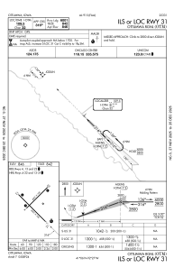
IAC chart of KOTM
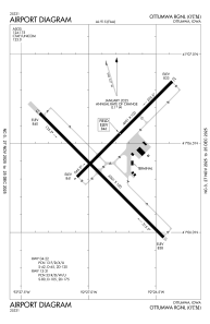
 ADC chart of KOTM
 Satellite view of KOTM
ADC chart of KOTM
Satellite view of KOTM
Sorry, we have no imagery here.
Sorry, we have no imagery here.
Sorry, we have no imagery here.
Sorry, we have no imagery here.
Sorry, we have no imagery here.
Sorry, we have no imagery here.


KOTM - Ottumwa Rgnl
Located in Ottumwa, United States
ICAO - OTM, IATA - OTM
Data provided by AirmateGeneral information
Coordinates: N41°6'26" W92°26'50"
Elevation is 845 feet MSL.
Magnetic variation is -01° East View others Airports in Iowa
Operational data
Special qualification required
Current time UTC: 02:10:31
Current local time:
Weather
METAR: KOTM 040153Z AUTO 15009KT 10SM OVC048 14/04 A2967 RMK AO2 SLP050 T01440039
TAF: KOTM 032334Z 0400/0424 15012KT P6SM SCT040 BKN060 FM040600 16013G22KT P6SM OVC030 PROB30 0407/0411 4SM -SHRA OVC015 FM041100 16011G19KT 6SM -SHRA OVC019 PROB30 0411/0413 4SM -TSRA OVC008CB FM041300 15011G19KT P6SM -RA OVC009 FM041600 15015G24KT 3SM -SHRA OVC005 FM042000 13017G26KT 1 1/2SM -RA OVC004
Communications frequencies: [VIEW]
Runways:
| RWY identifier | QFU | Length (ft) | Width (ft) | Surface | LDA (ft) |
| 04 | 45° | 4601 | 100 | OTHER | |
| 22 | 225° | 4601 | 100 | OTHER | |
| 13 | 135° | 6001 | 100 | CONC | |
| 31 | 315° | 6001 | 100 | CONC |
Airport contact information
Address: Ottumwa United States
