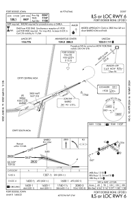
IAC chart of KFOD
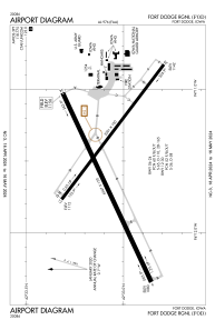
 ADC chart of KFOD
 Satellite view of KFOD

ADC chart of KFOD
Satellite view of KFOD
Sorry, we have no imagery here.
Sorry, we have no imagery here.
Sorry, we have no imagery here.
Sorry, we have no imagery here.
Sorry, we have no imagery here.
Sorry, we have no imagery here.


KFOD - Fort Dodge Rgnl
Located in Fort Dodge, United States
ICAO - FOD, IATA - FOD
Data provided by AirmateGeneral information
Coordinates: N42°33'4" W94°11'31"
Elevation is 1156 feet MSL.
Magnetic variation is 02° East View others Airports in Iowa
Operational data
Special qualification required
Current time UTC: 02:10:33
Current local time:
Weather
METAR: KFOD 040156Z AUTO 17007KT 10SM OVC039 13/06 A2961 RMK AO2 SLP045 T01280056
TAF: KFOD 032334Z 0400/0424 16011KT P6SM SCT025 OVC040 FM040400 15009KT P6SM OVC020 PROB30 0404/0406 4SM -SHRA OVC002 FM041300 13008KT P6SM OVC004 PROB30 0413/0416 4SM -SHRA OVC002 FM041600 12010KT 2SM -SHRA OVC003 FM041800 12011KT 3SM -RA OVC004 FM042100 04013G21KT 1 1/2SM -RA OVC003
Communications frequencies: [VIEW]
Runways:
| RWY identifier | QFU | Length (ft) | Width (ft) | Surface | LDA (ft) |
| 06 | 65° | 6547 | 150 | ASPH | 6547 |
| 24 | 245° | 6547 | 150 | ASPH | 6547 |
| 12 | 127° | 5301 | 100 | ASPH | 5301 |
| 30 | 307° | 5301 | 100 | ASPH | 5301 |
Airport contact information
Address: Fort Dodge United States
