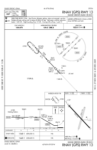
IAC chart of KEAG
 ADC chart of KEAG
 Satellite view of KEAG

ADC chart of KEAG
Satellite view of KEAG
Sorry, we have no imagery here.
Sorry, we have no imagery here.
Sorry, we have no imagery here.
Sorry, we have no imagery here.
Sorry, we have no imagery here.
Sorry, we have no imagery here.


KEAG - Eagle Grove Muni
Located in Eagle Grove, United States
ICAO - EAG, IATA -
Data provided by AirmateGeneral information
Coordinates: N42°42'36" W93°54'58"
Elevation is 1132 feet MSL.
Magnetic variation is 03° East View others Airports in Iowa
Operational data
Special qualification required
Current time UTC: 22:35:28
Current local time:
Weather at : KCAV - Clarion Muni ( 13 km )
METAR: KCAV 282215Z AUTO 15009KT 10SM FEW026 A3008 RMK A01
Communications frequencies: [VIEW]
Runways:
| RWY identifier | QFU | Length (ft) | Width (ft) | Surface | LDA (ft) |
| 01 | 16° | 2389 | 120 | GRASS | |
| 19 | 196° | 2389 | 120 | GRASS | |
| 13 | 136° | 3500 | 60 | CONC | |
| 31 | 316° | 3500 | 60 | CONC |
Airport contact information
Address: Eagle Grove United States
Satellite view of KEAG
Sorry, we have no imagery here.
Sorry, we have no imagery here.
Sorry, we have no imagery here.
Sorry, we have no imagery here.
Sorry, we have no imagery here.
Sorry, we have no imagery here.