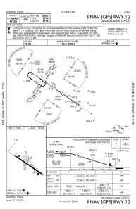
IAC chart of KDNS
 Satellite view of KDNS

Satellite view of KDNS
Sorry, we have no imagery here.
Sorry, we have no imagery here.
Sorry, we have no imagery here.
Sorry, we have no imagery here.
Sorry, we have no imagery here.
Sorry, we have no imagery here.


KDNS - Denison Muni
Located in Denison, United States
ICAO - DNS, IATA - DNS
Data provided by AirmateGeneral information
Coordinates: N41°59'10" W95°22'49"
Elevation is 1274 feet MSL.
Magnetic variation is 04° East View others Airports in Iowa
Operational data
Special qualification required
Current time UTC: 02:00:40
Current local time:
Weather
METAR: KDNS 040135Z AUTO 14008KT 9SM FEW028 SCT037 BKN075 11/06 A2957 RMK AO2
Communications frequencies: [VIEW]
Runways:
| RWY identifier | QFU | Length (ft) | Width (ft) | Surface | LDA (ft) |
| 12 | 124° | 5000 | 75 | CONC | |
| 30 | 304° | 5000 | 75 | CONC | |
| 18 | 179° | 3200 | 60 | GRASS | |
| 36 | 359° | 3200 | 60 | GRASS |
Airport contact information
Address: Denison United States
Satellite view of KDNS
Sorry, we have no imagery here.
Sorry, we have no imagery here.
Sorry, we have no imagery here.
Sorry, we have no imagery here.
Sorry, we have no imagery here.
Sorry, we have no imagery here.