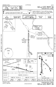
IAC chart of KDBQ
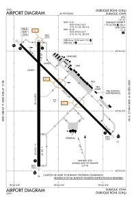
 ADC chart of KDBQ
 Satellite view of KDBQ

ADC chart of KDBQ
Satellite view of KDBQ
Sorry, we have no imagery here.
Sorry, we have no imagery here.
Sorry, we have no imagery here.
Sorry, we have no imagery here.
Sorry, we have no imagery here.
Sorry, we have no imagery here.


KDBQ - Dubuque Rgnl
Located in Dubuque, United States
ICAO - DBQ, IATA - DBQ
Data provided by AirmateGeneral information
Coordinates: N42°24'7" W90°42'34"
Elevation is 1076 feet MSL.
Magnetic variation is 03° East View others Airports in Iowa
Operational data
Special qualification required
Current time UTC: 02:04:25
Current local time:
Weather
METAR: KDBQ 040153Z 15013KT 10SM SCT050 SCT065 07/01 A2975 RMK AO2 SLP084 T00720006
TAF: KDBQ 032320Z 0400/0424 16012KT P6SM OVC050 TEMPO 0408/0412 6SM -RA BR BKN025 FM041200 17011G20KT 6SM -RA OVC015 FM041500 14012G20KT 2SM -RA BR OVC005 FM042000 12010G20KT 2SM -RA BR OVC004
Communications frequencies: [VIEW]
Runways:
| RWY identifier | QFU | Length (ft) | Width (ft) | Surface | LDA (ft) |
| 13 | 135° | 6502 | 100 | CONC | 6502 |
| 31 | 315° | 6502 | 100 | CONC | 6502 |
| 18 | 180° | 6327 | 150 | CONC | 6327 |
| 36 | 360° | 6327 | 150 | CONC | 6327 |
Airport contact information
Address: Dubuque United States
Satellite view of KDBQ
Sorry, we have no imagery here.
Sorry, we have no imagery here.
Sorry, we have no imagery here.
Sorry, we have no imagery here.
Sorry, we have no imagery here.
Sorry, we have no imagery here.