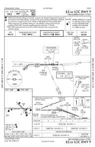
IAC chart of KCID
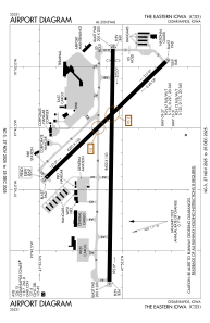
 ADC chart of KCID
 Satellite view of KCID

ADC chart of KCID
Satellite view of KCID
Sorry, we have no imagery here.
Sorry, we have no imagery here.
Sorry, we have no imagery here.
Sorry, we have no imagery here.
Sorry, we have no imagery here.
Sorry, we have no imagery here.


KCID - The Eastern Iowa
Located in Cedar Rapids, United States
ICAO - CID, IATA - CID
Data provided by AirmateGeneral information
Coordinates: N41°53'5" W91°42'39"
Elevation is 869 feet MSL.
Magnetic variation is 02° East View others Airports in Iowa
Operational data
Special qualification required
Current time UTC: 02:14:28
Current local time:
Weather
METAR: KCID 040152Z 15012KT 10SM OVC048 12/02 A2971 RMK AO2 SLP064 T01170017
TAF: KCID 032320Z 0400/0424 15012KT P6SM OVC050 TEMPO 0407/0411 6SM -RA BR BKN025 FM041100 17011G20KT 6SM -RA OVC019 FM041400 14012G20KT 3SM -RA BR OVC007 FM042000 12010G20KT 2SM -RA BR OVC004
Communications frequencies: [VIEW]
Runways:
| RWY identifier | QFU | Length (ft) | Width (ft) | Surface | LDA (ft) |
| 09 | 91° | 8600 | 150 | CONC | 8175 |
| 27 | 271° | 8600 | 150 | CONC | 8175 |
| 13 | 136° | 6200 | 150 | CONC | 6200 |
| 31 | 316° | 6200 | 150 | CONC | 6200 |
Airport contact information
Address: Cedar Rapids United States
