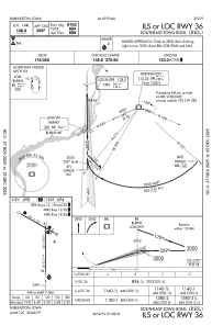
IAC chart of KBRL
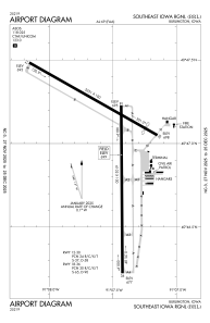
 ADC chart of KBRL
 Satellite view of KBRL
ADC chart of KBRL
Satellite view of KBRL
Sorry, we have no imagery here.
Sorry, we have no imagery here.
Sorry, we have no imagery here.
Sorry, we have no imagery here.
Sorry, we have no imagery here.
Sorry, we have no imagery here.


KBRL - Southeast Iowa Rgnl
Located in Burlington, United States
ICAO - BRL, IATA - BRL
Data provided by AirmateGeneral information
Coordinates: N40°46'59" W91°7'32"
Elevation is 698 feet MSL.
Magnetic variation is 01° East View others Airports in Iowa
Operational data
Special qualification required
Current time UTC: 02:06:26
Current local time:
Weather
METAR: KBRL 040153Z AUTO 16012G22KT 10SM BKN060 BKN075 12/M01 A2975 RMK AO2 SLP075 T01171006
TAF: KBRL 032320Z 0400/0424 14012G20KT P6SM OVC050 FM040600 16012G20KT P6SM OVC035 WS020/20040KT TEMPO 0406/0410 6SM -RA BR BKN025 FM041000 17012G22KT P6SM -SHRA OVC035 WS020/20040KT FM041200 15012G22KT 3SM RA BR OVC005 FM042000 13015G25KT 2SM -RA BR OVC004
Communications frequencies: [VIEW]
Runways:
| RWY identifier | QFU | Length (ft) | Width (ft) | Surface | LDA (ft) |
| 12 | 120° | 5351 | 100 | CONC | 5350 |
| 30 | 300° | 5351 | 100 | CONC | 4850 |
| 18 | 180° | 6102 | 100 | CONC | 6102 |
| 36 | 360° | 6102 | 100 | CONC | 6102 |
Airport contact information
Address: Burlington United States
